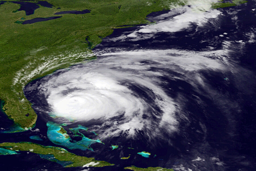
In hurricane Irene bull's eye, coastal North Carolina braces
Loading...
| Beaufort, N.C.
The current track for hurricane Irene has the potential Category 3 hurricane crashing into the US near Beaufort, N.C., a rugged, idyllic coastal outpost known for its dolphins and wild horses.
“We're the center of the bull's eye,” says Beaufort Fire Marshall Ben Barnett.
Expected to impact nearly 70 million Americans along the country's most populated stretch – from the Outer Banks of North Carolina to New England – the hurricane's likely first strike on the Southern Outer Banks, known as the Crystal Coast, will be an indicator of the extent of potential damages in more populated areas to the north.
If current tracks hold, some damage could be catastrophic, with damages in the billions of dollars.
Governors along the Atlantic Coast began limited, and some mandatory, evacuations on Friday for residents of low-lying areas, with New York City Mayor Michael Bloomberg saying he will decide Friday whether to order evacuations for Coney Island.
Ocean City, Md., is under a mandatory evacuation order, as is Cape May, N.J. Parts of Virginia Beach are under mandatory evacuation orders as the US Second Fleet continued to move its ships from Norfolk into the open Atlantic.
In North Carolina, coastal roads began clogging Friday morning as visitors and locals continued to leave the Outer Banks before the last ferry Friday night.
After lashing the Bahamas, Irene moved at a leisurely 15 miles per hour through warm Atlantic waters, weakening slightly to a Category 2 storm and then strengthening again Friday morning, flirting with a Category 4 designation, meaning sustained winds of more than 140 miles per hour.
The eye of the storm is currently 400 miles south of Cape Hatteras, N.C., moving on a northerly track.
Beaufort residents such as Perry Barrow, owner of Outer Banks Ferry, watched the storm track jag to the west on Thursday, forcing him to change his preparations. On Friday, he was packing up goods and moving his boats, which offer tours of local pirate haunts and historic whaling grounds, to safer harbors.
“This is making a lot of people very nervous,” he says.
One boat captain, who gave his name only as Joey, laughed along to gallows humor outside the Beanfork Coffee Shop in Beaufort as he prepared to ride out the storm aboard his 28-foot sailboat. “We'll probably be an oyster reef by the time this is over,” he said.
“I only laugh because I'm stressed,” he added.
"This is the hard part right now, the waiting," says another captain, calling himself Keith, who has decided he'll spend the storm on land, not on his boat.
Hurricane Irene is poised to be the largest storm to make landfall in the US since hurricane Katrina in 2005.
And it would be the first major hurricane to hit North Carolina since hurricane Isabel in 2003, and the first to strike the Crystal Coast directly since hurricane Hazel in 1954. Measuring 360 miles wide, the storm could become the biggest hurricane to hit New England since hurricane Bob in 1991, a storm which it resembles. Bob reached Category 3 strength before reaching New England as a major tropical storm.
Here on the Crystal Coast, authorities have begged homeowners along the vulnerable Atlantic Beach to leave, but many have chosen to stay. If the eye does wander ashore here, that will mean the Outer Banks, the tender slip of barrier islands that juts like a baseball mitt into the Atlantic, will bear the brunt of the storm's dangerous northeast quadrant, where storm surges could top 10 feet. As of Thursday, some OBX-ers were determined to ride out the storm.
“If it comes ashore as a Cat. 3 on this track, everything and everyone on the Banks will be gone,” says Joey, the Beaufort captain.
North Carolina declared a state of emergency Thursday, opening access to federal assets to help government agencies respond to the disaster.
To help with a potentially disastrous aftermath, the government has stationed mountains of supplies, including water and generators, at Fort Bragg, one of the country's largest military installations. In North Carolina, an emergency declaration also means concealed weapons carry permits are invalid for the duration – another grim reminder of the potential of a storm to cause civil unrest.


