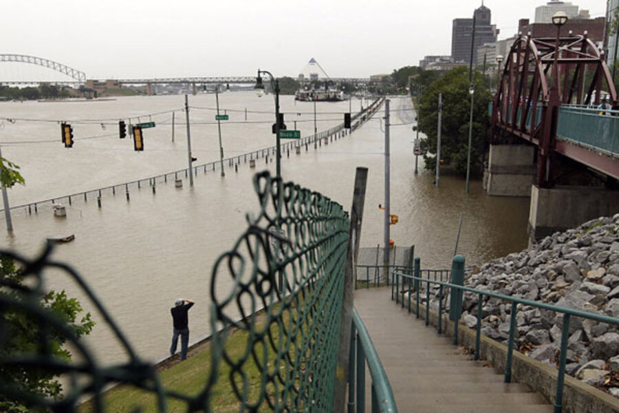
Watery week ahead as Mississippi floodwaters hit Memphis, move downriver
Loading...
Record high floodwaters are expected to crest throughout the southern Mississippi Delta next week, starting in Memphis, Tenn., Wednesday and continuing through New Orleans by May 17. As momentum builds, the bulging waters moving down the Mississippi River are backing up tributaries that feed into it, resulting in evacuations, school cancellations, and road closures as water builds.
Some areas in and around Memphis are already under water, as river levels sit at 46 feet, breaking the record of 45.8 feet set during the historic 1927 flood. The National Weather Service forecasts that the Mississippi will crest there at 48 feet Wednesday and is expected to remain standing for as many as four days.
Officials in surrounding Shelby County are issuing evacuation notices at about 1,100 homes that sit in low-lying areas along the river. In Memphis, 959 homes are being asked to evacuate. By late Friday, at least 300 people were counted at shelters at local churches.
IN PICTURES: Mississippi river floods
Water is already resting at the foot of Beale Street, the historic music corridor running through the city’s downtown. Preventing Memphis from massive flooding is the bluff upon which it sits, which elevates the downtown from immediate danger.
The most torrential waters are expected in communities that rest in lowlands along the Mississippi’s tributaries. Evacuations are on order along the Loosahatchie River, where floodwaters have shut sections of Interstate 51. Similarly, the White River in neighboring Arkansas forced the closure of sections of Interstate 40. People living along Nonconnah Creek, Wolf River, and Big Creek are also being asked to evacuate.
The rain stopped on Saturday, bringing good news to an area where people are worried that further accumulation would worsen levee conditions. According to the US Army Corps of Engineers, the Memphis levee system is built to withstand a water flow of 2.4 million cubic feet per second. The current water flow is perilously close, at 2.2 million cubic feet per second.
Rain is not forecast in the area again until Thursday.
As water moves through the upper Delta, areas further downstream are bracing for even higher water levels.
The highest are expected in Natchez and Vicksburg, two historic Mississippi towns. The river's level in Vicksburg is expected to rise to 57.5 feet on May 20 and 64 feet in Natchez on May 22 – breaking records set during the 1927 and 1937 floods.
Bob Anderson, a spokesman for the Mississippi Valley Division of the US Army Corps of Engineers, says higher floodwaters are expected to penetrate areas along the Yazoo River, which feeds into the Mississippi near Natchez. A series of backwater levees will be activated to relieve pressure from the main levees that sit adjacent to the river, he says.
In Louisiana, the Army Corps is set to open two floodways designed to divert the flow away from New Orleans and channel it into the Gulf of Mexico. Without use of the floodways, water would be expected to crest at 19.5 feet in New Orleans on May 24, just six inches below the top of the levee system there.
Located between Baton Rouge, La., and New Orleans, the Bonnet Carre Spillway will open Monday at 8 a.m. The Morganza floodway, located north and west of Baton Rouge near the Atchafalaya River Basin, may open as early as Thursday.
The Morganza was last used in 1973. However, the Bonnet Carre was opened nine times since 1937, most recently in 2008. Mr. Anderson says approximately 20,000 people will be negatively affected by the use of the Morganza Floodway, which could remain open for several weeks. Widespread flooding along the floodway is expected to reach 25 feet in height.
On Friday, the Army Corps notified residents of Pointe Coupee, St. Landry, St. Martin, Iberia, Iberville, St. Mary, and Terrebonne parishes, all located along the Morganza, to contact local officials about potential evacuation plans.
“Anytime you build a structure or a home in a floodway, it’s always taking a bit of a risk,” he says.


