Haiti earthquake: Why the Caribbean is a mini ring of fire
Loading...
| Boston
Last week's devastating earthquake in Haiti and yesterday's magnitude 5.9 aftershock (downgraded by the US Geological Survey after an initial report estimated it at 6.1) serve as tragic reminders that as idyllic as many spots in the Caribbean Sea may seem, they can periodically be dangerous too.
The region is no stranger to volcanoes and earthquakes, thanks to the interaction of one of the smallest – yet one of the most complex – crustal plates on the planet.
Known as the Caribbean Plate, this slowly migrating, slowly morphing patch of Earth's crust exhibits virtually every feature found on the world's largest plates.
It's home to a spreading center – one of the deepest on Earth – where new material emerges from deep beneath the crust to replenish the sea floor. Portions of it are bounded by subduction zones, where one crustal plate plunges beneath another. Some of these trigger the formation of volcanoes. It has a platelet, a kind of smaller plate within a plate, on which the island of Hispaniola – home to Haiti and the Dominican Republic – rides. And it exhibits the kind of long, side-slipping faults similar to California's San Andreas Fault.
"The Caribbean is very complicated," says Jian Lin, a geophysicist at the Woods Hole Oceanographic Institution in Woods Hole, Mass. "It's small to start with, but you have everything in plate tectonics in this very small region."
Those processes have helped raise and sculpt a set of islands – from the Caymans to the Antilles – that are picturesque, geologically active, and occasionally dangerous as populations have grown.
The Jan. 12 temblor centered near the Haitian capital of Port-au-Prince has vaulted it to the top of the list of most devastating quakes to hit the Caribbean. UN and other officials estimate that the death toll will reach well into the tens of thousands of people.
That eclipses the previous record-holder – a quake that hit the Leeward Islands in 1843. That struck as a magnitude 8.3 quake, killing 5,000 people, according to US Geological Survey data.
It took a volcanic eruption on Martinique in 1902 to approximate the devastation last week's quake inflicted on Haiti. That year Mt. Pelee erupted, hurling ash and superheated gas toward the town of St. Pierre. The eruption destroyed the town and killed some 30,000 people.
The Caribbean Plate was born deep beneath the ocean some 90 million to 100 million years ago, Dr. Lin explains, during a virtual tectonic tour of the Caribbean. It likely emerged via a "hot spot" in the Pacific at a time when the world's land masses were configured in a dramatically different way. Instead of leading to towering volcanic islands, the way a hot spot has formed the Hawaiian chain, the hot spot spawning the Caribbean Plate extended over a wide region, with magma oozing through fissures and vents and spreading horizontally to form a vast undersea plateau.
Floating and diving plates
In plate tectonics, buoyancy counts for a lot. What is now the Caribbean Plate is more buoyant than typical ocean crust. And it's less buoyant than the crust that makes up continents.
Over time, the North and South American continents migrated west, separated by a small ocean. As they moved, their ocean encountered the more-buoyant Caribbean Plate. It rode over the top of the oceanic crust separating the two continents.
Today, the plate is bounded to the west by the Cocos Plate, which dives under the Caribbean plate just west of Central America. This movement built and sustains the region's volcanoes.
At the Caribbean Plate's southern boundary it slides under the South American Plate. To the east of the Leeward Islands as well as northeast of Hispaniola, the North American Plate is diving beneath the Caribbean.
Where the faults lie
Where plate meets plate head-on, as they do along the subduction zone east of the Leewards, volcanoes form, Lin continues. But where the collision along a subduction zone strikes at an angle, most of the collision energy goes into forming long fault zones, such as the Septentrional-Oriente Fault.
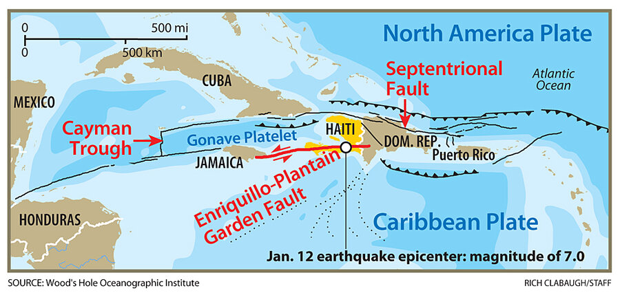
The Septentrional-Oriente Fault zone starts northeast of Puerto Rico, stretches west across the north coast of Hispaniola, slides past the southern end of Cuba, and reaches the Cayman Islands. Then, it takes a quick jog south along the Cayman Trough, the plate's spreading zone.
As for Hispaniola, it sits on a plate fragment known as the Gonave Platelet. The Septentrional-Oriente Fault forms its northern boundary. Its southern boundary is the now-infamous Enriquillo-Plantain Garden Fault, the source of Haiti's current seismic woes.
This fault and an associated undersea trench south of the Dominican Republic form the northern boundary of the Caribbean plate. The motion along the boundary carries the Caribbean Plate eastward along the zone -- the direction of last week's slip.
In 2008, a team led by University of Texas seismologist Paul Mann and Purdue University's Eric Calais calculated that if the accumulated strain along the Enriquillo-Plantain Garden Fault snapped in one event, the resulting earthquake would hit magnitude 7.2. But the projection lacked specifics in time and location. Dr. Mann points out that this section of the fault has never been studied in ways that would yield an average recurrence rate for major earthquakes.
Researchers have raised similar red flags concerning the Septentrional-Oriente Fault.
Carol Prentice, a US Geological Survey scientist who has studied the fault as it runs through the Dominican Republic's Cibao Valley, estimates that the fault is overdue for a major quake. Based on geological studies she and colleagues conducted, they estimate that if the accumulated strain were to be released in a single event, it could trigger a quake with a magnitude of at least 7.5.


