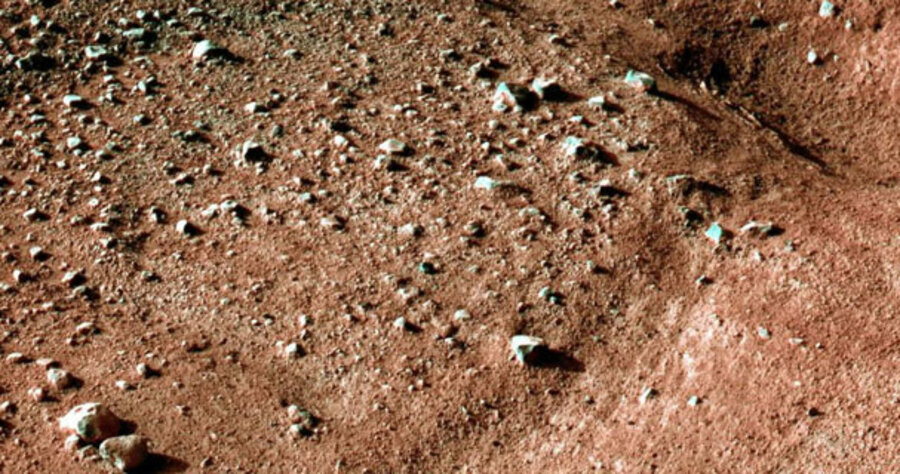
Phoenix Mars Lander prepares to begin excavation
Loading...
For the Phoenix Mars Lander, it’s time to get down to business.
After an historic, near-perfect landing on a broad, flat, pebble-strewn stretch of the Martian Arctic on May 25, the chemistry lab on legs is undergoing tests this week in preparation for its months-long hunt for water ice under the planet’s surface. The key question: Could this region, like its earthly counterparts, represent a suitable habitat for simple forms of life?
“This is a scientist’s dream,” said University of Arizona researcher Peter Smith, the project’s lead scientist, as he displayed initial photos from the lander of its environment at a post-landing briefing Sunday evening.
On Monday, the Phoenix team released a remarkable image of the lander, cocooned in its protective shell, hanging from its parachute during descent. The image was taken by the Mars Reconnaissance Orbiter's HiRise camera while the orbiter passed overhead to relay data from the lander.
One of the lander’s first tasks is to use its stereo camera, mounted on a mast, to take a 360-degree panorama of the site. The lander returned its first images of its landing site Sunday evening. The first 120-degree sweep may be available as early as Tuesday. The images will help mission planners build a 3-D model of the area that they will use to guide the robotic arm and its scoop to the excavation spots of choice.
Compared with dramatic scenes of the heavily sculpted Martian landscapes taken from orbit, the Phoenix landing site appears somewhat boring. But to mission scientists, boring is beautiful. A lack of boulders or cratered terrain significantly improved the likelihood of a safe landing. The surface – out to a featureless horizon – is broken into irregular polygon-shaped patches perhaps 15 feet across. The pattern looks very similar to those seen on the floors of the Dry Valleys of Antarctica or regions of northern Canada and Alaska.
On Earth's subsurface, ice contracts with frigid winter temperatures, opening cracks. In the Arctic, water can enter the cracks, freeze, and form ice wedges. In the much drier Antarctic, soil falls in, forming narrow furrows on the surface. As temperatures warm and the ice expands, the wedges halt further expansion, causing the patches to buckle in the middle – similar to the forms the lander has already experienced. The research team hopes the robotic arm and its digging scoop are within range of one of these areas between patches. If they were to find ice wedges, that would strongly imply at least the fleeting presence of liquid water during the melt season, Mr. Smith explains.
Indeed, the polygonal patches around the landing site seem to be smaller than the ones that appear in Mars Reconnaissance Orbiter images of the area, he says. The team may be seeing "polygons within polygons within polygons," he speculates.
Before Mr. Smith and his colleagues can begin to dig in their cosmic sandbox, however, engineers plan to evaluate the lander’s various systems to ensure it can support the initial 92-day (90 sols, or Martian days) mission. For instance, engineers are monitoring the performance of the solar panels and batteries through several Martian sols to get a more precise fix on how much power the electrical system can deliver. Continued analysis of the power system, along with a better sense for how dust builds up on the solar panels throughout the summer, will help inform a decision on whether to extend the mission for up to 60 sols once the primary science goals are achieved, says Ed Sedivy, the spacecraft manager with Lockheed Martin, which built the lander.
The arm-and-scoop combination will also undergo a shake-down period before digging begins in earnest sometime next week. The digging and analyzing will be a tedious, if exhilarating process, mission planners note. The lander has the capacity to analyze 22 soil or ice samples. But each sample takes several days to process, collectively eating up 70 to 80 days, Smith says.
Indeed, tote up everything else the lander is tasked to do, including digging up the samples and conducting weather studies, “and you’re already into the extended mission,” he says.
Even as planners prepare the lander for its experiments, National Aeronautics and Space Administration officials continue to marvel at the precision with which the mission’s navigation team targeted the landing site. Initial indications suggested that Phoenix landed on the boundary of its so-called landing ellipse – which contains the target spot plus some margin for error. But the exquisitely timed sequence of events after reentry still put the lander in a perfect location for the scientists.
Edward Weiler, who heads NASA’s science mission directorate, noted that traveling 422 million miles and landing where the craft did was akin to hitting a golf ball in Washington and having it land in the cup in Sydney, Australia. To which Jet Propulsion Laboratory Director Charles Elachi added: Don’t forget, the hole is moving, too.


